Trail Walking Florac Trois Rivières - Le Sentier des Couronnes - Florac - Photo

Le Sentier des Couronnes - Florac

 tracegps
tracegps

User

© OpenStreetMap contributors
Length
Length
15.3 km
Max alt
Max alt
1063 m
Uphill gradient
Uphill gradient
653 m
Km-Effort
Km-Effort  
24 km
Min alt
Min alt
546 m
Downhill gradient
Downhill gradient
648 m
Boucle
Boucle
Yes
Creation date :
2014-12-10 00:00:00.0
Updated on :
2014-12-10 00:00:00.0

(4 Reviews)

Walking
Walking
5h00
Difficulty : Difficult

Scan this QR Code to open this trail in the SityTrail application

FREE GPS app for hiking

Logo SityTrail SityTrail

IGN / Geographical institutes

Download SityTrail from the App Store Download SityTrail from Google Play

Logo SityTrail SityTrail World

The world is yours!

Download SityTrail from the App Store Download SityTrail from Google Play Download SityTrail on Huawei AppGallery

About

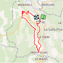
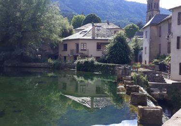
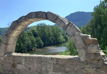
Trail Walking of 15.3 km to be discovered at Occitania, Lozère, Florac Trois Rivières. This trail is proposed by tracegps.

Description

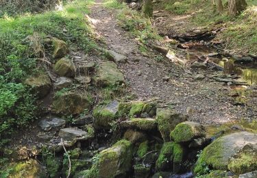
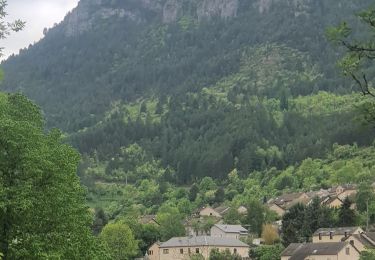
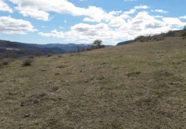
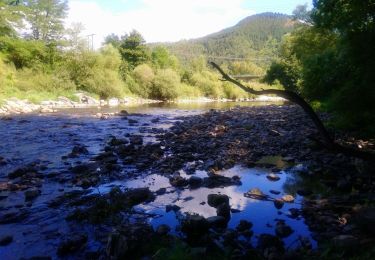
Randonnée entre causse et falaises avec une vue sur les Cévennes et plus si beau temps dégagé. Parking: sous le château (siège du Parc National des Cévennes) en centre ville vers la source du pécher. Sortir de Florac par le nord et gagner le lotissement des Grézes (sentier du Gralhon) puis le centre équestre de Gralhon. Remonter par des sentiers aux antennes sur le causse. Après la table d'orientation descendre sous la bordure du causse en suivant un bon sentier jusqu'au "rochefort" et sous les "jalses de Croupillac" emprunter le sentier qui descend vers Croupillac. Avant le hameau, partir au nord en suivant un balisage vert qui rejoint un chemin carrossable que l'on suit. Descendre dans l'épingle de la route et trouver la suite un peu plus loin sur la droite, une sente qui descend fort pour gagner la source du pécher et le parking.

Elevation profile

Photos

Positioning

Country:
France
Region :
Occitania
Department/Province :
Lozère
Municipality :
Florac Trois Rivières
Location:
Florac
Start:(UTM)
547281 ; 4907920 (31T) N.

Comments

Please log in to post a review or rate the element


Trails nearby

Trail Walking Bédouès-Cocurès - Stevenson Bedouès Barre des Cévennes  - Photo
Walking
GUIDE
nadinebondoux

Walking

Difficult
Bédouès-Cocurès, Occitania, Lozère, France
20 km | 28 km-effort
6h 4min
No
Trail On foot Florac Trois Rivières - Florac - Photo
On foot
PRO

On foot

Medium
Florac Trois Rivières, Occitania, Lozère, France
15.5 km | 24 km-effort
5h 30min
Yes
Trail Walking Florac Trois Rivières - Panoramique des couronnes - Photo
Walking
GUIDE
nadinebondoux

Walking

Difficult
Florac Trois Rivières, Occitania, Lozère, France
14.9 km | 23 km-effort
5h 43min
Yes
Trail Walking Florac Trois Rivières - Les Cévennes sentiers sympas  - Photo
Walking
sereton

Walking

Medium
Florac Trois Rivières, Occitania, Lozère, France
7.2 km | 11.6 km-effort
2h 43min
Yes
Trail Walking Florac Trois Rivières - Etape 8 Florac/Cassagnas - Photo
Walking
Nathalie. Mercier

Walking

Medium
Florac Trois Rivières, Occitania, Lozère, France
20 km | 26 km-effort
5h 20min
No
Trail Walking Bédouès-Cocurès - 14-05-2023 E9 Bédouès - Barre des Cévennes  - Photo
Walking
GUIDE
Kargil

Walking

Very difficult
Bédouès-Cocurès, Occitania, Lozère, France
19.6 km | 27 km-effort
6h 11min
No
Trail Walking Florac Trois Rivières - de Florac à St Enimie par le Causse de Sauveterre - Photo
Walking
canardDenis

Walking

Very difficult
Florac Trois Rivières, Occitania, Lozère, France
27 km | 41 km-effort
9h 26min
No
Trail Walking Cans et Cévennes - Autour du MAZEL via CROUPILLAC - Photo
Walking
Dominique48

Walking

Medium
Cans et Cévennes, Occitania, Lozère, France
4.2 km | 6.5 km-effort
1h 48min
Yes
Trail Walking Florac Trois Rivières - Monteils  - Photo
Walking
Gegetop

Walking

Medium
Florac Trois Rivières, Occitania, Lozère, France
12.2 km | 17.1 km-effort
3h 40min
Yes


Close
My subscriptions